• LiDAR Mapping aka Remote Sensing
  • Aerial Terrestrial LiDAR Services
  • Airborne LiDAR Bathymetry Services
  • LiDAR Drone Mapping Services
  • 3D Laser Scanning via Helicopter
  • LiDAR for Civil Engineering Projects
  • LiDAR for Land Surveying Projects
  • 3D Mapping Services Topographic Maps
  • 3D LiDAR Modeling + Orthorectified Images

LiDAR Hawaii offers LiDAR Mapping Services via helicopter or drone for Aerial Terrestrial LiDAR scanning as well as Bathymetric Airborne Drone LiDAR Mapping Services and Sonar or Echosounding Drone Mapping Services.

LiDAR Hawaii

LiDAR Drone Mapping + LiDAR Drone Bathymetry + Sonar Drone Mapping Services

LiDAR Hawaii LiDAR Mapping Services 3D Digital Terrain Model DTM

LiDAR Hawaii: Our LiDAR Services

Looking for LiDAR Mapping Services for your next big project? You’ve come to the right place! LiDAR Hawaii offers a full range of Aerial Terrestrial LiDAR and Airborne LiDAR Bathymetric LiDAR Services. 

LiDAR Mapping Technology is increasingly popular for creating high-resolution 3D Maps. It is great for a wide range of applications from civil engineering to architecture to land surveying. LiDAR laser scanning or remote sensing is perfect for urban development, environmental conservation, and erosion control from rising sea-levels.

LiDAR Hawaii offers reliable and accurate LiDAR services. We produce some of the best LiDAR Maps available in the industry today. We’re a local State of Hawaii company! We offer Airborne LiDAR Bathymetry and Aerial Terrestrial LiDAR Mapping on all islands as well as worldwide.

Aerial Surveying's new high-resolution Bathymetric LiDAR Mapping system is unique. In short, LiDAR Hawaii possesses the most advanced suite of LiDAR mapping capabilities on the planet.

LiDAR Hawaii LiDAR Mapping Services

LiDAR Hawaii Services include LiDAR Bathymetry Mapping

LiDAR Hawaii is proud to announce its newest service… Airborne LiDAR Bathymetry. We use a cutting-edge 2-in-1 LiDAR System mounted on a gas-powered drone. Our new system does both Airborne LiDAR Bathymetry Mapping and Aerial Terrestrial LiDAR Mapping. This allows us to map both the ocean floor terrain and shoreline or coastline terrain for projects along the coast. LiDAR Hawaii is now able to measure and map underwater features and the seafloor at a centimeter-level depth resolution for the first time ever. Our new system provides a cost-effective solution to the traditional SHOALS method of collecting Bathymetric LiDAR data making it perfect for civil engineering or other coastal projects.

LiDAR Hawaii Services include LiDAR Drone Mapping

Our new cutting-edge gas-powered drone now makes it possible to perform LiDAR Mapping Services for up to 3 hours compared to battery-operated drones with about twenty minutes of fly time. This allows us to perform Bathymetric LiDAR Mapping over the open ocean with our new 2-in-1 Airborne LiDAR Bathymetry and Aerial Terrestrial LiDAR System. We also mount a smaller LiDAR Mapping system on our gas-powered drone for smaller projects. LiDAR Hawaii is now able to produce LiDAR data topographic maps on projects of 500 acres or less. This new system provides a cost-effective alternative to our helicopter mounted Aerial Terrestrial LiDAR system used for large civil engineering or other shoreline projects.

LiDAR Hawaii Services include Land Surveying LiDAR Topographic Maps

LiDAR Drone for Topographic Mapping

LiDAR Technology is changing the way land surveyors create Topographic Maps. And LiDAR Drones are revolutionizing the way land surveyors collect LiDAR data. LiDAR produces more accurate terrain and elevation data. LiDAR Topographical Maps are more accurate than interpolated maps created from GPS data. Drone LiDAR Mapping is much more efficient for data collection than GPS aka Global Positioning Systems. LiDAR Drones are a faster way to collect terrain and elevation data. This makes LiDAR Mapping more cost-effective. LiDAR Drone Mapping is more accurate, faster, and less costly. Therefore, LiDAR technology is the best Land Surveying solution for Contour Mapping.

LiDAR Hawaii Services include Georeferenced Photo Mosaics + Orthoimages

Georeferenced Orthoimages + Photo Mosaics

LiDAR Hawaii creates georeferenced orthoimages using 3D Mapping technology. 3D Mapping produces 3D representations of your project site or acreage from your LiDAR data. This allows us to create High-Resolution Georeferenced Orthoimages and Photo Mosaics with incredible accuracy. LiDAR Hawaii creates detailed Orthoimages and Photo Mosaics no matter how rugged or inaccessible the terrain. Georeferenced Orthoimages and High- Resolution Photo Mosaics are quickly becoming the standard for terrain visualization thanks to LiDAR Mapping. Georeferenced Orthoimages and Photo Mosaics have a wide range of applications like civil engineering projects and urban development. 

LiDAR Hawaii Services include Digital 3D Mapping + 3D Modeling

Digital Terrain Models (DTMs) + Digital Elevation Models (DEMs)

LiDAR technology is an advanced and widely used technologies for 3D Modeling. 3D LiDAR Modeling creates three-dimensional models from LiDAR point cloud data. LiDAR data is used to create highly accurate Digital Elevation Models (DEMs), Digital Surface Models (DSMs) and Digital Terrain Models (DTMs).  3D Digital Modeling is an essential tool for a variety of applications like civil engineering design, architectural design, construction project planning, environmental conservation planning, and more.

LiDAR Hawaii Services include Topographic Mapping

Created from LiDAR Data Point Clouds

For many years, interpolated Topographic Maps were created using aerial photography. Today Topographic Maps are created with highly accurate real time LiDAR data. LiDAR Hawaii now has an Airborne Terrestrial LiDAR system small enough to mount on our new gas-powered drone. LiDAR Mapping of smaller projects of up to 500 acres is now cost-effective. We use a helicopter mounted with a LiDAR laser scanner or remote sensor for larger projects.

Frequently Asked LiDAR Questions

Our Hawaii LiDAR company now specializes in Airborne LiDAR Bathymetry and Bathymetric LiDAR for civil engineering projects, urban development, environmental conservation, coastline mapping, shoreline mapping, erosion control for sea-level changes, flood plain analysis, coral reef mapping for coral reef research, and ocean floor terrain mapping.

Our Hawaii LiDAR company now specializes in LiDAR drone mapping services using a high-tech gas-powered drone making LiDAR data acquisition cost effective for smaller LiDAR projects.

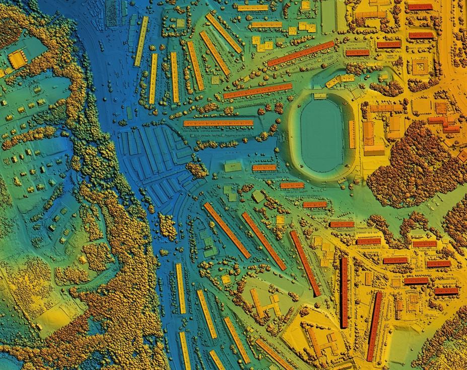
AstraLite Edge a patented 2-in-1 Topographic + Bathymetric LiDAR Mapping System with the following features:

  • Cutting-edge Airborne LiDAR Bathymetry System that now solves the limitations of traditional Bathymetric or SHOALS systems.
  • For the first time ever, measuring underwater features at centimeter-level depth resolution is now possible.

Rock Robotics R2A LiDAR System a complete LiDAR + RGB Solution with the following features:

  • Complete aerial terrestrial LiDAR mapping solution.
  • Equipped with the new Livox Avia sensor with a Novatel GNSS high-accuracy Inertial Labs IMU.
  • Equipped with a 24MP Sony camera for high resolution aerial photographs for georeferenced orthoimagery.

Riegl 280ii LiDAR system manufactured from a series of major components:

  • Laser 600-1000 nm LiDAR lasers are common.
  • Scanner dual axis scanner.
  • Photodetector solid state photo detectors.
  • Navigation System- GPS Global Positioning System.
  • Equipped to LiDAR Helicopter.

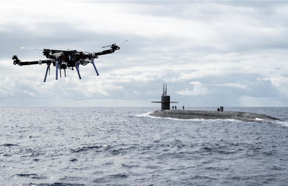
Our new gas-powered SkyFront LiDAR drone flies up to 3 hours now making it possible to collect bathymetric LiDAR data point clouds over the open ocean. We also use our gas-powered drone for mapping aerial terrestrial LiDAR projects of 500 acres or less.

We mount our Hawaii LiDAR scanners on a gas-powered drone or a helicopter for collecting LiDAR elevation data for topographic mapping for civil engineering projects. Our LiDAR data is merged with georeferenced high resolution aerial photos or orthoimagery (formerly done using photogrammetry) to create accurate photo mosaics and precise visualizations.

Our Hawaii LiDAR company utilizes LiDAR laser scanning to merge high resolution georeferenced aerial photographs aka orthoimages to produce highly accurate photo mosaic maps. Georeferenced high resolution aerial photographs, orthoimages, and photo mosaics are included with every LiDAR Hawaii project.

LiDAR Hawaii uses the latest photograph stitching software to create High Resolution Photo Mosaics for every LiDAR Project. Our Photo Mosaics are Orthorectified to match your LiDAR Project Site on the ground. LiDAR Hawaii also provides High Resolution Aerial Photographs of your project.

We still do aerial terrestrial LiDAR Mapping using an R44 Helicopter for larger civil engineering and land surveying projects of 500 acres or less. In addition, we now offer LiDAR Mapping for smaller projects of 500 acres or less. We mount our new smaller LiDAR Mapping system on our gas-powered drone. LiDAR Hawaii is now producing LiDAR topographic maps aka contour maps as part of our land surveying services.

LiDAR technology uses ultraviolet light to reimage certain objects. The extraordinary thing about LiDAR is that it targets a wide range of materials. Aerial LiDAR data point clouds collected at high altitudes from an aircraft or drone map terrain at a minimum resolution of 3 cm. Our LiDAR Hawaii company uses both helicopter LiDAR systems and LiDAR drone systems for laser scanning, remote sensing, and LiDAR topographic land surveying. LiDAR possibilities are limitless.

Our Hawaii LiDAR company uses a state-of the art LiDAR scanners mounted on either a helicopter or gas-powered drone collecting the following AutoCAD compatible LiDAR data:

  • First Return LiDAR Data Point Clouds.
  • Second Return LiDAR Data Point Clouds.
  • Third Return LiDAR Data Point Clouds.
  • Fourth Return LiDAR Data Point Clouds.
  • Active x, y, z Data Points
  • Georeferenced LiDAR Data Point Clouds
  • AutoCAD + MicroStation Compatible Data

Founded in the late 1950s, LiDAR technology was discovered shortly after the laser was invented. Laser scanning was combined with laser focused imaging to calculate distances by measuring the time it takes the laser beam to return. LiDAR is an acronym originating from the terms “light” and “radar”. LiDAR as an acronym for Light Detection And Ranging began in the 1970s as the true definition of LiDAR.

LiDAR Hawaii’s LiDAR Mapping systems collect active x, y, z data points in real time. LiDAR Hawaii produces AutoCAD + MicroStation compatible x, y, z data points. Our LiDAR Data is superior to interpolated data generated with Photogrammetry.

LiDAR Hawaii includes high resolution Geo-referenced Orthoimages with every LiDAR Mapping Project. Our orthorectified images combine aerial photograph characteristics with the geometric qualities of maps. All of our Orthorectified images are ground truthed by our in-house land surveying department.

What is LiDAR?

Laser scanning or remote sensing is a LiDAR Mapping technology. LiDAR illuminates targets with laser lights using algorithms to measures distance. LiDAR scanning captures LiDAR data point clouds using topographic elevations for contour mapping. LiDAR technology is used for 3D modeling or 3D mapping. LiDAR has active x, y, z data points. LiDAR is used for topographic mapping. It is also used to create digital terrain models (DTMs) and digital elevation models (DEMs). LiDAR data is combined with orthorectified high resolution aerial photographs to make photo mosaic maps. LiDAR is great for projects for civil engineers, land surveyors, and urban developers.
Hawaii's Premiere LiDAR Company LiDAR Hawaii
Our Hawaii LiDAR Company Provides Global LiDAR Services
  • Airborne LiDAR Bathymetry
  • Aerial Terrestrial LiDAR
  • Ground Truthing of LiDAR Data
  • LiDAR Drone Mapping
  • LiDAR for Civil Engineering Projects
  • LiDAR for Land Surveying Projects
  • LiDAR for Ocean Floor Terrain Mapping
  • LiDAR for Shoreline Surveys
  • LiDAR for Shoreline Certificates
  • LiDAR for Mapping Coastal Erosion
  • LiDAR for Flood Plain Analysis + FEMA Certificates
  • LiDAR for Coastline Mapping
  • LiDAR for Architectural Design
  • LiDAR for Architects
  • LiDAR for Urban Development
  • LiDAR for Environmental Conservation
  • LiDAR for Resort Development
  • LiDAR for Subdivisions
  • LiDAR for Subdividing Land Subdivisions
  • LiDAR for Golf Course Design
  • LiDAR Scanning Using a Helicopter
  • LiDAR Survey
  • LiDAR Drone Survey
  • LiDAR Data Point Clouds
  • LiDAR Data Collection
  • LiDAR for Environmental Conservation
  • LiDAR for Erosion Control
  • LiDAR for Agriculture Farming
  • LiDAR for Wind Farm Optimization
  • LiDAR for Solar Photovoltaic Farms
  • LiDAR for Geology
  • LiDAR for Military
  • LiDAR for Coral Reef Mapping 
  • LiDAR for Contour Mapping
  • LiDAR for Archeology 
  • LiDAR for Hawaiian Burial Sites
  • Drone LiDAR Mapping
  • Mapping LiDAR Projects
  • Bathymetric LiDAR
  • Topographic Maps with Elevations
  • Digital Mapping
  • Active x, y, z Data Points
  • LiDAR Data Point Clouds
  • AutoCAD Compatible LiDAR Data
  • MicroStation Compatible LiDAR Data
  • LiDAR 3D Models
  • LiDAR 3D Maps
  • Orthorectified High Resolution Aerial Photographs
  • High Resolution LiDAR Photo Mosaics
  • LiDAR Orthoimages
  • LiDAR Geo-referenced High Resolution Orthoimages
  • Multi Spectral Images
  • LiDAR Shoreline Maps
  • LiDAR Topographic Maps
  • LiDAR FEMA Maps
  • LiDAR Coastline Maps
  • LiDAR Digital Elevation Models
  • LiDAR Digital Terrain Models
  • LiDAR Survey Maps
  • LiDAR Subdivision Maps
  • Bathymetric LiDAR Maps
  • LiDAR Drone Survey Maps
  • LiDAR Georeferenced Aerial Photos
  • LiDAR High Resolution Aerial Photography
  • LiDAR Data Point Clouds
  • LiDAR Land Survey Maps
  • LiDAR High Resolution Photo Mosaics
  • LiDAR Contour Maps
  • Geo-referenced Photo Mosaics
  • Orthorectified Photo Mosaics
  • Geo-referenced High Resolution Aerial Photographs
  • Contour Maps with Elevations
  • Photo Stitching
  • Aerial Photos
  • Digital Maps
  • Photo Mosaics
  • DEMs
  • DTMs

Many mainland LiDAR companies hired to do LiDAR projects in the State of Hawaii end up subcontracting our local Hawaiian company Aerial Surveying Inc. to do their actual remote sensing or laser scanning for the LiDAR data collection on your project. These mainland companies charge you extra in order to cover the cost of subcontracting Aerial Surveying, Inc. to collect your Hawaii LiDAR data on the islands. Don’t be fooled …we are a local Hawaii island company established in the State since 2003. We will always bid your Hawaii LiDAR projects lower than any mainland company since we do not carry the high mobilization costs or any subcontracting overcharges.

LiDAR Hawaii Land Surveying Services
State of Hawaii Licensed Professional Land Surveyor No. 10743
  • Aerial Drone Photo Overlay Survey Maps Hawaii
  • LiDAR Topographic Mapping Hawaii
  • Construction Stakings
  • As-Built Survey Maps Hawaii
  • Ingress Egress Easement Maps Hawaii
  • Metes and Bounds Legal Descriptions Hawaii
  • Flood Plain Analysis Hawaii
  • FEMA Certification Hawaii
  • Shoreline Survey Certificate Hawaii
  • Shoreline Mapping Hawaii
  • File Plan Maps Hawaii
  • Land Court Maps Hawaii
  • LiDAR Topography Mapping Hawaii
  • ALTA Survey Maps Hawaii
  • Metes and Bounds Legal Descriptions Hawaii
  • Construction Stake-outs Hawaii
  • Land Development Subdivisions Hawaii
  • Pad Height Elevation Certificate Hawaii
  • Roof Height Elevation Certificate Hawaii
  • Property Easements Hawaii
  • Land Surveys Hawaii 
  • Consolidation Resubdivision Survey Maps Hawaii
  • K1 Escrow Staking Hawaii
  • K2 Escrow Survey Hawaii
  • LiDAR Contour Maps with Elevations
  • Subdivision Planning and Mapping Hawaii
  • Contour Mapping Hawaii
  • Shoreline Survey Certificate Hawaii
  • Shoreline Mapping Hawaii
  • Flood Plain Analysis Hawaii
  • FEMA Certification Hawaii
  • File Plan Maps Hawaii
  • Land Court Maps Hawaii
  • As-Built Survey Maps Hawaii
  • ALTA Survey Maps Hawaii
  • LiDAR Topo Maps with Elevations Hawaii
  • Boundary Line Marking Hawaii
  • Property Line Marking Hawaii
  • Property Staking Hawaii
  • Property Surveys Hawaii

Servicing all Islands in the State of Hawaii

State of Hawaii Board of Professional Engineers, Architects, Surveyors and Landscape Architects

To View My Professional Vocational Land Surveying License Click on MyPVL (hawaii.gov)

Or Contact Us Directly ~ Mobile 808.960.4006 ~ eMail [email protected]