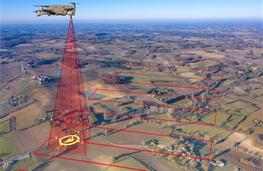
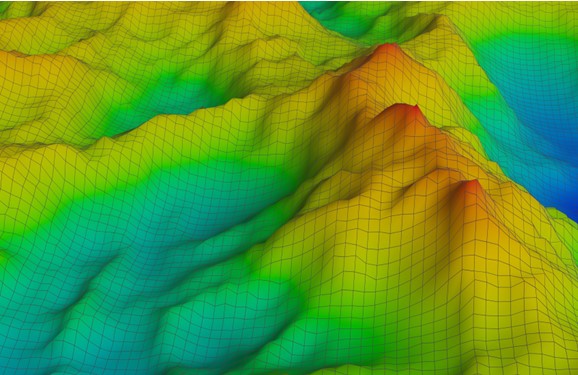
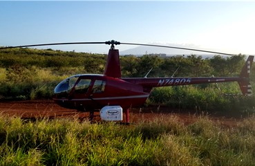
Aerial terrestrial LiDAR mapping services include helicopter laser scanning and drone remote sensing. Our new LiDAR drone system makes LiDAR topographic mapping affordable for even small project. Mapping LiDAR is a great choice for civil engineering projects, urban development, environmental conservation, and land surveying projects.

LiDAR Mapping Services

hawaii-lidar-drone-mapping-services-aerial-terrestrial-lidar;

LiDAR Mapping Services

Our LiDAR mapping services are perfect for civil engineering projects, land surveying projects, urban development, mapping natural disasters and environmental conservation. Mapping with LiDAR saves time in the field which cuts project costs. Using our LiDAR laser scanner system mounted on a helicopter allows us to complete large projects in a matter of days. These same projects may take weeks or even months to complete with conventional land surveying methods. This includes traditional land surveying equipment like robotic total stations and GPS (Global Positioning Systems). LiDAR mapping services are a smart solution for topographic mapping.

In addition to remote sensing using a helicopter, we now perform aerial terrestrial LiDAR mapping using a drone. We also use our new gas-powered drone for bathymetric LiDAR services. This makes remote sensing or laser scanning affordable.

LiDAR Hawaii has a new cutting edge 2-in-1 LiDAR Mapping System. LiDAR Hawaii’s new Bathymetric LiDAR Mapping System if perfect for ocean floor terrain mapping. We now measure and map underwater features and the seafloor at a centimeter-level depth resolution. Our Airborne LiDAR Bathymetry system replaces traditional SHOALS Bathymetry. 

We mount our new Bathymetric LiDAR system on a gas-powered drone. Our dual LiDAR Mapping System allows us to remote sense or laser scan both seafloor terrain and shoreline or coastline terrain. This is a cost-effective solution to traditional Bathymetric SHOALS. 

LiDAR Hawaii is the perfect choice for your civil engineering coastal project, mapping shoreline erosion or coastline erosion caused by rising sea-levels or mapping natural disasters. Drone Mapping makes Bathymetric LiDAR affordable for projects along the coastline or shoreline. 


LiDAR Hawaii Mapping with LiDAR

What is LiDAR?

LiDAR is an acronym for Light Detection and Ranging. LiDAR is an active remote sensing system also known as active laser scanning, LiDAR uses a laser beam to penetrate vegetation and map land contours over large areas. LiDAR provides a cost-effective solution to creating topography maps covering large areas.

LiDAR systems generate light from a rapidly firing laser for ground measurements. This light travels from the laser, penetrating foliage while reflecting off of things like tree trunks, rock outcroppings, and buildings. The reflected light energy returns to the LiDAR sensor where it is recorded.

A LiDAR system measures the time it takes for emitted light to travel to the ground and back. This time is used to calculate the distance traveled. Distance traveled is then converted to elevation. LiDAR system measurements are made in conjunction with GPS systems and satellites to identify the actual x, y, z location of the light energy while an IMU or Internal Measurement Unit provides the orientation of the plane, helicopter, or drone in the sky.

LiDAR Hawaii LiDAR Systems

Mapping LiDAR with our state-of-the-art LiDAR systems guarantees accurate deliverables. Our in-house licensed land surveyor ground truths your LiDAR data. This ensures that your digital LiDAR data matches your project site on the ground. 

LiDAR mapping aka laser scanning or remote sensing saves time and cuts project costs. Using conventional land surveying methods like Robotic Total Stations and GPS for land mapping takes longer in the field. Like Photogrammetry, topographic maps created with GPS data are interpolated. 

LiDAR Mapping produces real time active x, y, z data points. This makes topographic maps created from LiDAR data points much more accurate.


Our LiDAR Mapping Equipment is listed below:

Our gas-powered drone mounted airborne LiDAR bathymetric system is the most advanced system available for mapping coral reefs and ocean floor terrain. Extended flight times of up to three hours compared to minutes with battery operated drones allows us to perform bathymetry work over the open ocean. Mounting our new state of the art LiDAR bathymetric systems on our gas-powered drone cuts project costs when compared to the traditional airplane mounted SHOALS system.

Riegl 280ii LiDAR Laser Scanner or Remote Sensing System

We mount a helipod containing our Riegl 280ii LiDAR scanner on an R44 Helicopter. This allows us to perform laser scanning or remote sensing at lower altitudes compared to using an airplane. Using a helicopter also allows us to make tighter turns on KMZ file flight lines. This reduces time and costs since your project is scanned much faster compared to using an airplane. It also allows us to land directly on the project site to set up our GPS base receivers. This also saves time and costs on your LiDAR Mapping project.


Our gas-powered drone mounted aerial terrestrial LiDAR system is the most advanced system available for terrestrial land mapping. The ability to mount our compact aerial LiDAR system on our gas-powered drones verses a helicopter or airplane makes smaller LiDAR projects cost effective. From a small subdivision lot to a few hundred acres, our drone mounted aerial terrestrial LiDAR system generates the most accurate real time data available for topographic mapping at an affordable price.

Our cutting-edge gas-powered drones from SkyFront, a start-up in Silicon Valley, fly for hours verses mere minutes of flight time when using drones running on regular lithium batteries. Our Sky Front Perimeter 8 gas-powered drones fly up to three hours. This saves time in the field as our drones do not have to be retrieved constantly for battery changes every 15 to 20 minutes. LiDAR Mapping Drones fly at lower elevations. Therefore, they provide more LiDAR scanned points per square meter. This results in much more accurate LiDAR mapping. LiDAR Hawaii produces some of the best topographic maps in the industry.

LiDAR Hawaii Services - LiDAR 3D Models + Orthoimages

LiDAR Hawaii LiDAR Mapping Deliverables are among the best in the LiDAR mapping business. Our in-house licensed land surveyor ground truths all LiDAR data to ensure its accuracy in relation to your project. LiDAR Mapping collects active x, y, z LiDAR data point clouds in real time. All of our LiDAR Hawaii LiDAR data is AutoCAD + MicroStation compatible.

  • Digital Terrain Models
  • Digital Elevation Models
  • 3D Maps
  • 3D Models
  • Orthoimages
  • Multi Spectral Images
  • Photo Mosaics
  • High Resolution Geo-referenced Aerial Photos
  • Topographic Maps
  • DTMs
  • DEMs
  • High Resolution Aerial Photographs
  • LiDAR Data Point Clouds
  • LiDAR Data 1st Return
  • LiDAR Data 2nd Return
  • LiDAR Data 3rd Return
  • LiDAR Data 4th Return
  • AutoCAD Compatible LiDAR Data Points
  • MicroSoft Compatible LiDAR Data Points
  • Active X, Y, Z Data Points
  • LiDAR Drone Photos